Tableau makes mapping pretty easy. The most common ones I've seen are:
It's important to clarify, that Tableau is not a GIS tool. Although it has mapping capabilities, it can't to spatial analysis (like calculate area size or create spatial relationships). There are also limitations when it comes to drawing points with lines and polygons, though there are some workarounds. A topic for another day.
Converters
I wanted to work with Calgary communities but first, I had to find the data. I thought the City of Calgary's polygons must be super accurate, so I went to this page and got myself some community boundaries. There were 7 formats available for download, and I started with the CSV one. But I soon realized that it's not a Tableau-consumable format, so my next task was to search for a way to get any of these 7 formats into a workable format.

Through chatting with some folks at work, I discovered that there are online converters that does it for you. I'm sure there are more, but the 2 that I use are:
Both worked with the community boundaries shapefile I downloaded from the City of Calgary Open Data web site, which consisted of 4 files (.dbf, .prj, .shp, .shx). But when I was working with another project for work, the file I used had 3 sets of shapefiles zipped together (21 files of .dbf, .prj, .sbn, .sbx, .shp, .shp.xml, .shx per file). For this bundle, the Safe converter converted them into 3 neatly packaged tde.'s just fine but the Alteryx converter wasn't able to pick them up until I separated them into 3 zipped files.
Tableau Polygon 101
To draw polygons in Tableau, you need to have at least the following fields:

I then dragged "Name" to Detail, and got all the points that has a name. Which, in this case, are all the Calgary communities:

Because I wanted to draw polygons, I needed to tell Tableau the order in which the points should be connected. This is determined by the "Path", which appears in the Marks menu when I changed the graph type to Polygon. Without the order the points should be connected by, the graph defaults to this:

Drag "Path" to Path, and the communities appeared as intended:

I connected the map with the 2016 Calgary census data and the Calgary secondary suites data, did some more formatting, and this is what I got:

This map shows me which communities has more/less secondary suites, but I also want to be able to zoom into the specific communities and see the exact location of the suites. So I made a second graph using the secondary suite's longitude and latitude and some basic information I find useful (ie. address).
Here's the final result:
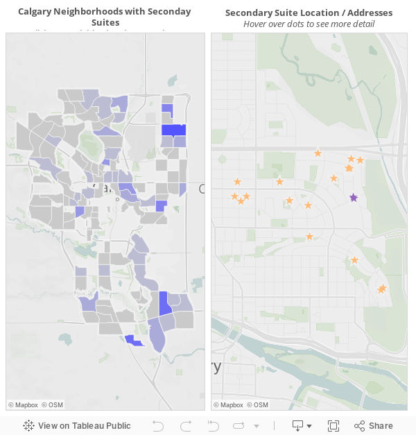
*Not sure if you noticed, but some communities (like Bridgeland/Riverside) don't have census information. This is because I used "Community Name" as the link between each data sources, so whatever community name was not an exact match will not have information about them.
BONUS - Dashboard Action: Hyperlinks
- Proportional symbol maps - ex. coloured dots on a map based on sales/profit
- Choropleth (or filled) maps - ex. coloured states based on population
See these maps and other types of maps on the Tableau online help page "Mapping in Tableau".
Tableau has most countries, states / provinces, and cities built in already (more info for the U.S. compared to other countries) so all you need to do is double click on the field and it should populate on the map. However, it's a bit of a different story when it comes to polygons, and I've been itching to try it out.
Converters
I wanted to work with Calgary communities but first, I had to find the data. I thought the City of Calgary's polygons must be super accurate, so I went to this page and got myself some community boundaries. There were 7 formats available for download, and I started with the CSV one. But I soon realized that it's not a Tableau-consumable format, so my next task was to search for a way to get any of these 7 formats into a workable format.

Through chatting with some folks at work, I discovered that there are online converters that does it for you. I'm sure there are more, but the 2 that I use are:
- Alteryx Tableau Shapefile to Polygon Converter
- Safe Software ArcGIS Shapefile to Tableau TDE - Free Online Converter
Both worked with the community boundaries shapefile I downloaded from the City of Calgary Open Data web site, which consisted of 4 files (.dbf, .prj, .shp, .shx). But when I was working with another project for work, the file I used had 3 sets of shapefiles zipped together (21 files of .dbf, .prj, .sbn, .sbx, .shp, .shp.xml, .shx per file). For this bundle, the Safe converter converted them into 3 neatly packaged tde.'s just fine but the Alteryx converter wasn't able to pick them up until I separated them into 3 zipped files.
Tableau Polygon 101
To draw polygons in Tableau, you need to have at least the following fields:
- Longitude
- Latitude
- ID (sometimes called Name)
- Order (sometimes called Path)

I then dragged "Name" to Detail, and got all the points that has a name. Which, in this case, are all the Calgary communities:

Because I wanted to draw polygons, I needed to tell Tableau the order in which the points should be connected. This is determined by the "Path", which appears in the Marks menu when I changed the graph type to Polygon. Without the order the points should be connected by, the graph defaults to this:

Drag "Path" to Path, and the communities appeared as intended:

I connected the map with the 2016 Calgary census data and the Calgary secondary suites data, did some more formatting, and this is what I got:

This map shows me which communities has more/less secondary suites, but I also want to be able to zoom into the specific communities and see the exact location of the suites. So I made a second graph using the secondary suite's longitude and latitude and some basic information I find useful (ie. address).
Here's the final result:
*Not sure if you noticed, but some communities (like Bridgeland/Riverside) don't have census information. This is because I used "Community Name" as the link between each data sources, so whatever community name was not an exact match will not have information about them.
BONUS - Dashboard Action: Hyperlinks
I added a "google search" hyperlink action in the Secondary Suite Location / Address graph so I can quickly look up information about the community I'm looking at.

This is done through dashboard actions → add action (URL).Simply type in any search term in google, then replace the term with the field in your dashboard that you want google to search by (ie. "community").
